The Tide-Line Is Not a Fixed Border
Learn how to read a tide line by comparing wet sand, seaweed, waves and weather, so you can interpret the shore without mistaking a trace for a boundary.
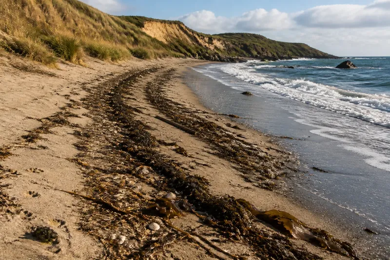
Where did the sea reach, and does the debris line show how far it will come next time? A tide line is a temporary trace, not a fixed border. Seaweed, shells, driftwood and litter can record recent water movement, but their position alone cannot identify the coast’s permanent edge or predict the next tide.
A tide line marks a recent reach, not a permanent edge
As the tide rises and falls, the water’s edge moves across sand, shingle, rock platforms and mudflats. After the water retreats, a dark band on sand, a fringe of foam, a stain on rock or stranded material may remain.
These marks can record different moments. A clean, damp edge may be recent; dried seaweed or weathered driftwood may have been left by an earlier tide and shifted by wind or people. Look at the material and its condition, but do not treat appearance as a reliable clock.
Wet, glossy wrack and brittle, bleached stems offer different clues. Neither tells the whole story without the shore’s shape and the recent weather.
Tides provide the moving background
The tide changes how far the sea reaches, but the visible distance across the shore also depends on its slope. On a gently sloping beach, a change in water level can move the water’s edge a long way across the sand. On a steep shingle shore, it may shift across a narrower strip.
Local features change the pattern. A seawall, harbour entrance, rock ledge or narrow creek can channel or interrupt water. At a sheltered inlet, water may creep up a muddy margin; on an open shore, breaking waves may obscure any neat wet boundary.
A wrack line is not a simple marker of a named tide level. It might show where floating material was deposited, where wave run-up stopped, or where several movements of water collected debris.
Waves can leave debris above the quiet water’s edge
Waves push water up the beach and draw it back. The highest reach of this swash can sit above the quieter water’s edge, particularly where waves arrive strongly or the shore slopes gently. Seaweed above the ordinary wet margin may therefore record wave action rather than an unusually high tide.
Wind direction, the stretch of open water across which wind blows, and the shape of the seabed and shore all affect waves. Offshore swell can continue towards a beach after local winds ease. Around headlands, groynes and harbour arms, waves may bend or reflect, leaving deposits in places that seem unexpected when judged only by the nearest waterline.
Look at how material is arranged. A curved strand of wrack, a fan of foam or a line of small fragments may suggest the direction water travelled. It is a clue to that movement, not a contour the sea will necessarily follow next time.
Weather can move or erase yesterday’s clues
Wind can push light seaweed inland, blow dry sand over a deposit or carry loose litter along the shore. Rain can wash marks from a beach face. A storm may rearrange material, while calmer weather can leave traces to dry, darken and become harder to interpret.
Sunshine and temperature also change how a mark looks. Wet sand darkens, then lightens as it dries; foam collapses; exposed seaweed loses its sheen. A clean-looking strip may have been exposed to fresh water or wind, while a dark band may simply lie in a damp hollow.
Compare several signs: the damp edge, the height and freshness of wrack, the direction of wind-blown material, and the state of the waves. Treat each as a clue with limits.
Read a tide line by comparing these clues
Does a seaweed line show the highest tide?
Not necessarily. Waves can carry seaweed above the quieter tidal reach, and wind or later water can shift it. Treat it as evidence that material was left behind, then compare it with other signs.
Can a tide line predict the next reach?
No. The next tide arrives under its own combination of water level, waves, wind and local conditions. An earlier line gives context, not a forecast.
Why are there several lines of debris?
Different tides and wave events can leave separate deposits, while wind and later swash can move or merge them. Material may also persist through several cycles, leaving a layered record rather than one clear boundary.
Is the wet edge the same as the tide line?
The wet edge usually marks where water has recently touched the surface, but it can change quickly as water retreats or swash runs up. A debris line may remain higher or farther inland after the surface dries.
Use a simple shore checklist to compare the evidence
Before interpreting a line, record what you can see and decide what each clue does—and does not—support. A field notebook or phone note is enough.
- Check whether the sand is damp at the water’s edge; if the damp margin is clear, record it as a recent water-contact clue, but if it is indistinct, do not use it to locate a precise reach.
- Check whether wrack is glossy and wet or dry and brittle; if it is fresh, treat recent deposition as possible, but if it is weathered, allow for an older deposit and later movement.
- Check whether debris forms one band or several; if bands differ in freshness, record them separately, but if they overlap, avoid assigning them to a single tide or event.
- Check whether waves are breaking strongly or arriving gently; if swash reaches high on the beach, consider wave run-up, but if waves are slight, keep other causes in view rather than assuming the line marks the tide.
- Check whether wind has blown loose material inland; if its direction and the debris pattern align, allow for wind movement, but if they do not, do not attribute the deposit to wind alone.
- Check for a seawall, rock ledge, creek or other shore feature; if one is shaping the water’s path, describe that local setting, but if the beach is open, do not assume a nearby feature explains the line.
Work through the clues before naming the line
Imagine you arrive at a sandy cove after a breezy night. For this invented example, suppose you see a dark wet edge near the water, dry broken kelp farther inland beneath the dunes, and a few glossy strands between them. Waves are still running up the beach, and the wind has been blowing towards the dunes.
First, note the wet edge as recent contact with water, not as the full reach of the sea. Next, record the dry kelp as older or weathered material, while allowing that wind may have shifted it inland. Then note the glossy strands and active swash as signs of more recent wave movement. The resulting interpretation is that the cove holds deposits from different movements; the available clues do not establish one exact high-water mark. The trade-off is useful context without a false claim of precision.
Write down the time, shore type, wind direction and whether waves are small or forceful. “Fresh kelp below dry wrack” is more informative than “the sea reached here”. On a later visit, compare the pattern rather than expecting the same edge to remain.
Keep a tide line separate from an official coastal boundary
A visible line can help explain recent contact between water and land. It may suggest where waves ran, where floating material gathered and how weather altered the beach. It cannot, without further context, define a stable boundary or describe every condition the shore experiences.
If you are documenting a beach, photograph the line alongside a recognisable feature such as a rock or groyne, with enough surrounding shore to show its setting. For questions about official coastal boundaries or access rights, consult the relevant local authority or a qualified professional.
Use “tide line” as a dated observation: a trace left by moving water, shaped by waves and weather, and liable to change before you return.